
One of the nearest long distance trails to home, the Lough Derg Way stretches for approx 70 km and having done a couple of sections and loops on it previously, I wanted, before the summer was out, to complete the whole thing in one go.
Travelling through three counties it has an easy trailhead to get to on public transport, starting in Limerick city and then following the tow path of the disused Guinness or Park canal to a short leg along the Shannon. Crossing it into Clare alongside the old Errina canal and the Ardnacrusha power station head race you rejoin the river to enter O’Briensbridge.
From there it’s another waterside walk for a couple of km before heading up on small backroads to Killaloe, over the bridge into Tipp and a long ascent on tarmac and moorland path up and over the Arra Mountains with views across Ireland.
Cross country from there to the shores of Lough Derg, which the trail stays close to for the rest of its winding route to the finish at Dromineer. I believe there are plans to extend the way to the top of the lake at Portumna which would then also include Co Galway.
My bus to Limerick was 40 minutes late so i didn’t get going from the Hunt Museum till nearly 4 o’clock, setting my sights on camping up somewhere around O’Briensbridge roughly 15kms away.

Turning my back on the busy shopping streets I followed the old Limerick Navigation Canal, opened in 1799 and closed in 1960, it avoided shoals on the Shannon and allowed passage up to Lough Derg and from there into the Grand Canal to Dublin a journey that took 4 days.
Passing by the sunken wreck of a barge and the derelict warehouses I stopped on the old quay with its cut stone work and abandoned crank, once used for loading and unloading the cargo , and marvelled at how a once busy transport route, teeming with industry was now, literally, a backwater.


Back in 1831 it would have cost me 2pence to travel by boat to O’Briensbridge and 100,000 people a year used the route. Now as we left the city behind,(and above), the canal was a place for graffiti artists and wildlife.


And pedestrians of all kinds.
Unfortunately I hadn’t seen the comment on the Irishtrails website about the route being closed on the University of Limerick campus so as i approached the confluence of Park canal and river it was a bit of a shock to come up against harris fencing and warning signs.
Fortunately “desire paths” as they are known had forged a route through, round and over the many obstacles. It’s hard to stop a determined walker on his passage of choice. A refurbished track was being laid from the uni into town which will be great in the future but was a bit of a hassle for me.


Then I was in the clear again alongside the river, with people out enjoying the sunshine.


Looming out of the woods by my side, the remains of a tall stone building appeared. This was Plassey Mill a six story corn mill from 1824 which, thanks to a 10ft drop in water level here, was the most productive mill in the area when it was operated by the Russell family, themselves the most renown millers in Munster. For some reason the corner tower was left when the rest of the building was demolished in the 50s.

This was once a tricky section for the horse drawn barge men. The towpath alongside the river was so high and narrow that the horses often fell into the river and at times of flood would be completely submerged, forcing men with long sticks to go ahead and feel for the path beneath the water. A little further along was a greater challenge, to cross the 450ft of the Shannon and get into the Errina Canal on the Clare side. The river now carries a fraction of the water it did before Ardnacrusha hydrostation was built. The head race of the power plant, above O’Briensbridge, takes the first 400 cubic metres of flow, leaving the old course of the river a mere 10, unless of course, as all to often happens these winters, the ESB has more than enough.
Back in the day it was a struggle to cross against the currents and passengers and horses would have to be transferred to smaller vessels and ferried or winched across.( Mind you, not as much as a struggle as when the Navigation first opened. There was no tow path for horses and the barges were manhauled up the canal and sailed or paddled on the fast flowing river section.)
A bridge needed to be built and in 1842 the Black Bridge was finally opened, carrying in 1 week over 4000 passengers and 76 horses.

Although still tresspassed upon by fisherman it is now closed and I had to use the more modern Plassey road bridge at the uni.
The next section on the Errina canal was very tranquil. Less than 5km from the city I was in a green and leafy corridor with water to my left and cows grazing the fields to my right. Faint shouts came from the distant playing fields and a poignant memorial to a fellow walker left me contemplating his fate.


At the hump backed bridge guarded by a white goat I joined the dead end road that led, after about 3km, to the massive grassy banks of the Ardnacrusha head race. This is now the navigation course for any boat wanting to get from the Shannon to the Atlantic and involves a double chamber lock that drops 100ft at the dam end. Having manoeuvred our little boat through the locks of the Grand and the Barrow I’m impressed. The next biggest drop in the British Isles is 19ft I believe. When completed in 1924 the hydro scheme was the biggest in the whole world and produced more energy than the entire country used.


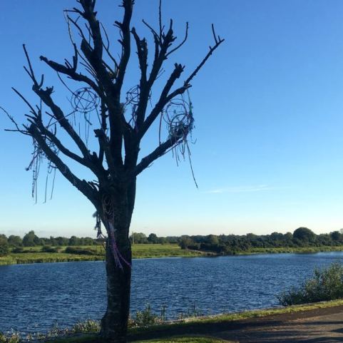
At Clonlara the Way rejoins the canal for a few km till it finishes at the Shannon again below O’Briensbridge. I had already hiked that section awhile ago and decided to continue on the slightly shorter option of following the head race into the village, where a tree drowned in the floods last winter had been decorated by the school kids.
With the evening drawing in I stopped briefly for some liquid refreshment in the only bar of many in the village still open for business and carried on into the sunset. Finding a quiet spot was not a problem and I made camp on the sheep mown grass of the bank and after a soup and sandwich , crawled into the tent under a full moon in the clear cobolt sky.
The clear sky remained in the morning as I broke camp and headed on atop the bank to the Parteen weir where the head race begins.The hills of Clare and Tipperary rose upon either side of the waters there as the Shannon widened into the bottom of Lough Derg.


I was soon directed away from the lakeshore onto a length of busy main road, thankfully turning off after a few 100m, and up a wooded lane with the beginnings of autumn showing in the leaves that formed a canopy above.

A sign at the top informed me this was on the route of Sarsfield Ride, the site of a dramatic episode in Irish history.
After the defeat of the Jacobites at the battle of the Boyne in 1690 James II fled to France and the remnants of the Irish army retreated to Limerick pursued by William who had swept down from the north seizing most of Leinster, intent on securing a river Shannon crossing at Limerick. Most of the command were for abandoning the city to Williams forces fearing the defensive walls were no match for his mighty new siege cannons on their way across the country to Williams camp just outside of Limerick. Not anticipating much resistance on their journey across subdued territory the convoy had only 100 men and Sarsfield, a general in the Irish army, hatched an audacious plan to intercept them.
Riding out under cover of darkness with 600 hand picked cavalry he headed north through friendly County Clare on the route I was now walking. Crossing at an unobserved bend in the river just north of Killaloe they stealthily made their way east into the hills. As luck would have it one of their scouts came across a wife of a Williamite soldier on the convoy whom he plied with whiskey and she revealed that the password for the siege train was “Sarsfield”.
The large convoy of formidable weaponry had made camp at Ballyneety just 10 miles from Williams position and the story goes that, when sneaking up on them after a long ride south, Sarsfield himself was challenged by a sentry for the password. “Sarsfield is the name, and Sarsfield is the man” he is said to have roared as his men swept in and quickly dealt with the sleeping troops.
Then gathering up the 150 wagons of stores, ammunition, powder, motor guns and canons whose mussels he rammed deep into the earth he set off a hell of an explosion that lit up the sky and was heard in the Williamite camp. Taking all of the enemies horses with them they hightailed it north around the top of Lough Derg at Portumna, back through Clare to arrive in Limerick as heroes.
Without the massive siege guns William had to wait for more to arrive from Waterford and the Irish had time to regroup. Morale was high after their victory and when the attack did come it was successfully beaten off, helped famously by many rock throwing local women.

And so, following in the footsteps, or hoof prints,of heroes I made my way to Killaloe for breakfast, fortifying myself for a long climb into the Arra Mountains of Tipperary on the other side of the Shannon.

The small road that led me up out of Ballina on the eastern side opened up views back down towards Parteen and across the Clare hills, with the forested slopes of Slieve Beamagh, the counties high point, rising above the waters.


The Way turned off up a narrow track strangely signposted to discourage cars.

The sun was shining brightly in the morning sky and I was shedding clothes as I climbed up into the heather and gorse covered moorland. I was left to wonder why so much of the land surrounding me had been left to go wild and who owned it.


Skirting the edge of forestry I joined the road the leading to the masts that sit on the summit of Tountinna at 460m and contemplated having a cooling dip in the Black Lough.

The high point of the Way reached, I stopped for lunch with a view and dried off my sweat soaked t-shirt and dew drenched tent. From here, with good eyesight (maybe binoculars) and visibility, you can see into 9 counties from the Twelvepins and Maumturks in the west to the Slieve Blooms and Wicklow Mountains in the east. The whole of Lough Derg is laid out before you complete, on this fine day, with a flotilla of boats competing in the Optimist dingy national championships at Dromineer. My phone camera could not cope.
The trail led steeply down from here to the site of the Graves of the Leinstermen, where the King of Leinster and his men, on the way to High King Brian Boru’s place to marry his daughter, were ambushed and killed in an attack planned by Brian’s wife Gormlaith who did not approve of the match. Seems harsh.

From here the route is changed from that shown on the ordinance survey maps to climb Laghtea Hill with its shiny steel cross replacing an earlier concrete one destroyed in a storm. The hills here are mainly slate and a lot of old mines and quarries dot the landscape

From here I started to have problems with the trail being overgrown and untended. Another steeply stepped path ran down through bracken and brambles adjoining a young plantation of conifers which threatened to overwhelm the track.


A short tarmac section later I was again directed off road, this time at the edges of fields through thistles, before arriving at a more accommodating farmers land who didn’t electric fence me into the nettles and prickles but instead trusted me to cross his land without causing damage, admiring the lake view on offer.

Reaching another road at a carpark known, not surprisingly, as The Lookout, I was way marked through a lovely section of mature mixed broadleaf woodland and down a lane past the award winning and attractive old church and graveyard at Castletown and the ruins that supplied the name.


Minutes later I gratefully joined the families cooling off in the waters of Lough Derg.

An hours R and R later I shouldered the pack once more and continued on through what was obviously a grand estate of many acres, the solid stone wall and forest of mature trees hiding whatever mansion lay within. The land here on the Tipperary side was seemingly much richer than the Clare side across the lake and the houses reflected that.
This was obviously a much desired location and exclusive looking lake view properties lined the road into Garrykennedy where the marina, busy gastro pub and expensive motors in the car park added to the effect. After a meal and pint I found myself a discreet camp.

The tent survived the nights rain and the day dawned fair, but it wasn’t due to stay that way.
With 25km left to go to Dromineer I was hoping to make quick progress around the lake before the weather changed. It started well enough on a stretch of road away from the village then the way marks lead me onto farmland where the grass was tall and wet and I had trouble finding the markers at times.
Leaving the cows behind I was led on a lovely path to a well managed woodland, well tended, with a trail to match.


Crossing a lane that led down to Youghal Harbour I followed a” new improved” farm track between park like grazing meadows, with huge mature trees generously strewn across them, that led me down to the enchanted setting of a holy well.

St Conlons Well had benefitted from the same facelift bestowed upon the land and woods around it and was “well” tended with a planting of flowers and a multitude of offerings hanging from the thorn tree. I have visited many a holy well and sadly a lot are falling into an unloved state of ruination but not this one. I filled my water bottle and was still awhile.

Unfortunately St Conlon could do nothing for the conditions of the Way that awaited me.
The manicured farmland gave way to wilder country with ragwort and thistle taking over neglected fields as I approached the low flat lake side area known as The Callows. This land was crisscrossed by wide and deep drainage ditches and the trail proceeded along the top of flood prevention banks that were choked with under, (and over), growth.

I struggled on constantly looking for a way around the obstacles. Everytime I tried a short cut across grazed fields I came up against another impassable ditch and had to fight my way back onto the bank of briars, nettles and waist high grass. To cross the ditches the route forced me a long way up them to a bridge, only to go a long way back down them on the other side. Frustrated by the nearly impenetrable scrub I wondered why the bridges couldn’t have been placed in more appropriate places.

I understand that many of the walking routes in Ireland rely on the good will of the farmers and that there is no “right to roam” and very few rights of way but I also know that under the National Walks Scheme launched by Minister Eamon O Cuiv nearly 2000 landowners on 49 trail routes are paid an average of €1000 annually to manage the tracks. In 2011 the local media reported that the Lough Derg way had been reconfigured and relaunched with many sections being taken off road. This had been achieved by an investment of €115,000 to “support landowners to maintain the trail”.


Walkers, especially those from abroad, do not want to hike long distances along the roads.But equally there is no point in leading them into an impenetrable morass on a National Waymarked Way with no escape route.

I found my escape route when I arrived, wet and weary, at a road. I had been looking forward to the lakeside sections and there was another 3 or 4km length coming up, but with the amount of time it had taken me to cover the last overgrown few km I didn’t think i’d make my rendezvous in Dromineer on time. And anyway I didn’t relish the thought of more fighting through the vegetation.
So I regretfully gave up on the Lough Derg Way and charted another course along the back roads for the remaining 5km or so. It was pleasant enough, passing through quiet farming backwaters and joining up with another walking route out of Dromineer.


Arriving just before the heavens opened i had time to check out the castle by the harbour then took shelter in a bar with a welcome bowl of leek and potato and await my lift.
Overall it was good hike but the overgrown section on The Callows was a serious flaw which could have denied me the best bits. I’ll have return at some stage to find out.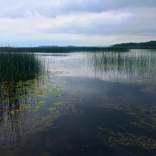

Steve
I just love short 2 or 3 day backpacking trips. Yours are particularly good in a different world to me.We all have issues with access and problematic footpaths but they become part of the experience.
LikeLike
They do indeed become part of the experience but not always in a positive way. I envy you your miles of public footpaths and rights of way. And your ability to take your dogs with you.
LikeLike
Didn’t quite understand that last comment about dogs. Are they not allowed on Irish walks??
We are privileged with our rights of way, dogs need to be on a lead on many though. Access areas seem to have their own rules, the fell above me [Fairsnape] allows dogs on one side of the fence and not on the other.
LikeLike
Pretty much all our long distance Ways are no dogs. They can go in forestry and on towpaths but basically not over any farmland.
LikeLike
Can’t believe that!
LikeLike
I’m sure there are sections that you could use boat and car to make a circular route for yourself. Is JD still out of action?
LikeLike
JD is moored outside the polytunnel. I may have to let go.
LikeLike
Sell it to electric picnic as the whiskey bar to the salty dog stage
LikeLike
Good read. Just wondering how did you approach the camping part? Is wild camping generally allowed on the trail or what are the rules there do you know
LikeLike
Colm. It is a good hike and I hope the overgrown stretch has been sorted out.
As far as camping is concerned I would say that if you are discrete , pitch camp late, leave early without any trace and respect the land and owner you will have no problems.
LikeLike