Month: September 2016

Beara Peninsular : Dursey and Derreen

img_1242

On a trip to our old stomping grounds in the south west to visit an ailing friend we had the pleasure of exploring a couple of places we had never been able to get to. Dursey Island and Dereen Gardens.

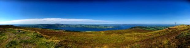
Connected to the mainland by the steel wires of Irelands only cable car, Dursey, on a gorgeous  summers day at least, is a stunningly beautiful and tranquil place. 6 1/2km long and 1 1/2 wide it rises from the sea like the whales that swim in the surrounding waters, (along with dolphins and basking shark).

Once home to around 300 people there are now only two permanent residents although the more benign months see an influx of visitors, both day trippers and others staying in the renovated houses in the three tiny villages.

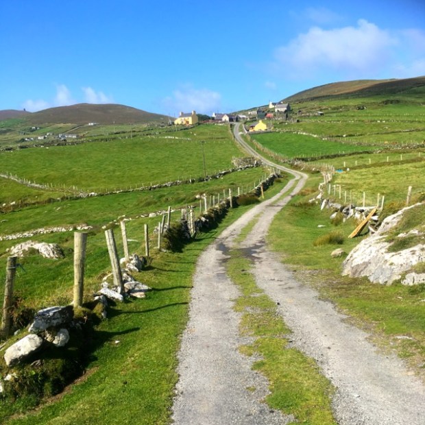
Our long drive down from Galway became seriously rugged when Serena, our sat nav, decided we would be up for some off roading  beyond Eyeries and sent us up a switchback track, through a couple of luckily unlocked gates and onto an old mountain pass that is now part of the Beara Way walking route. We couldn’t imagine how a well heeled tourist in a hire car would have reacted to the directions.

img_1171

The Tranny is made of sterner stuff and we relished the views from our high road as we climbed over the Slieve Miskish mountains and approached Allihies past the copper mines

img_1173

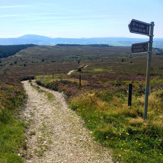
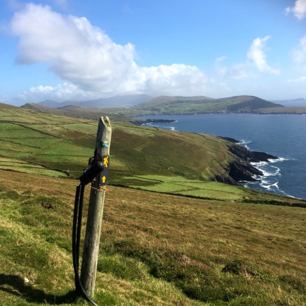
Keen to take full advantage of the fine weather we pushed on the remaining 10km to the end of the road where the signpost indicated a long swim would bring us to the mystical land of Tir na nOg.

img_1181

As you can see this also the starting point of the Beara Breifne Way, a 500km hiking route linking up 12 separate Ways that finishes way up in Leitrim and Cavan. This follows the route taken by Donal Cam O’Sullivan Beare, clan leader and Lord of Beara, and 1000 of his remaining followers after horrendous defeats in the Nine Years War. 2  very tough weeks later only 35 of them arrived at the allied O’Rouke castle in Leitrim.

Dursey is the trailhead of an even longer walk. It is the beginning of the European E8 that ends in Istanbul 4,700km further on. The Irish leg is about 600km. Making it’s weary way along half a dozen Irish Ways to Dublin and then across Europe we did a bit on the South Leinster Way a few weeks ago and a tiny bit in Slovakia last year.

In 1969 Dursey became one of a very few islands anywhere to be joined to the mainland by cable car. It made sense as the water separating them is well known for it’s dangerously strong rip currents and hidden reef. Storm waters can make a boat trip inadvisable for days on end so the cable car is a reliable means to transport nearly everything.

img_1176

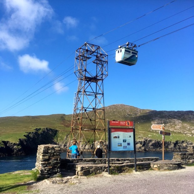
6 people, 4 sheep or 2 cows at a time, the car sails 80 ft above the waves in a quaintly dishevelled fashion with a little swaying and creaking and the passing view visible through the gaps in the floorboards.

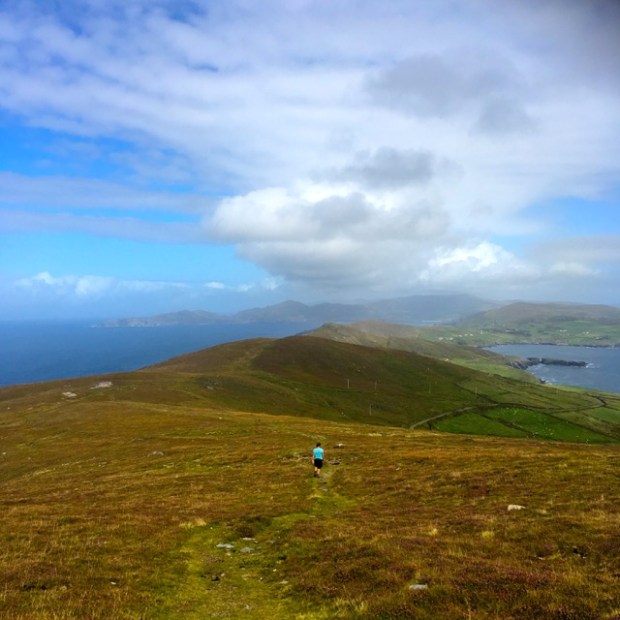
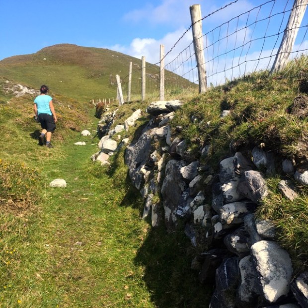
Arriving shortly at the islands station ( stuffed full of sacks of sheep wool for the export market) we headed off on our 14km hike.

img_1177

This was our third visit to an island this year and yet again it fuelled fantasies of an extended stay in a simple cottage, watching the weather approach across the atlantic, bird spotting, whale watching and producing a book or paintings or photography exhibition, or maybe merely reaching a state of true enlightenment.

Stone built tables and benches had been erected on the way to encourage the contemplation necessary to achieve the higher consciousness by imploring us to “sit down and take it easy”.img_1199

It hadn’t always been such a peaceful place however. We were looking out over the scene of the “Dursey Massacre” where 300 women, children and the aged of O’Sullivans clan gathered, ironically, for their safety in his castle stronghold were attacked by English forces and, tied back to back, were hurled from the cliffs or shot by musket. The chieftains family vault is in the graveyard of the monastic ruins of St Marys Abbey lying below us.

img_1197

Maybe the first, Neolithic, settlers had a tranquil time of it erecting their standing stones and alignments but the Vikings bought trouble and strife by using the island as a holding pen for the Irish slaves they had gathered before shipping them off to their fate elsewhere.

All was tranquil as we walked the islands only road up towards Ballynacallagh, the first of the 3 little villages that punctuate the route to the west end.

img_1201

The fields on either side, covered with a swathe of rich green grass, were fenced and grazed by cows and sheep but didn’t seem to have the old potato ridges that had been so prominent on our visit to Inishkea last month. Unlike that island there were quite a few smart homes in the villages, which have the luxury of electricity and water, but also many abandoned old stone farm buildings stoutly built to withstand the wild winds and driving rain.

img_1204

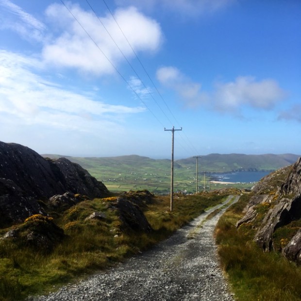
The sea glinted in the sunshine and the clear ozone filled blue sky meant we could see across it to the mountains of the mainland and the Sheeps Head and, dimly in the distance, the Mizen peninsulas.

img_1206

We had past a surprising number of rusting cars resting or rotting by the wayside but I guess once they had made the crossing by boat they weren’t going to be worth the expense of a return trip. Used by the local landowners to tend their stock they didn’t seem to need tax or test and there was little danger of collision on the single lane track only shared with a summer mini bus that shuttled tourists from one end to the other.

img_1189

Speed limits still (jokingly) applied !img_1212

The island was almost completely tree less although one fenced farmhouse garden we saw as we neared the final village of Tilickafinna proved it was possible to grow sheltering scrubs and the end house had a little plantation of pines struggling against the wind.

The tarmac ended and a path led on, up the open hillside, to our first view over the sea to the north and the islands of Bull Rock  and The Cow.img_1220

Bull Rock had an automated LED lighthouse nowadays but the old keepers house could still be seen on the summit of the sheer tower of stone. Easily desending towards the western head over the springy but shallow turf another old lighthouse appeared clinging to The Calf, a much smaller island that was overwhelmed by a storm in 1881.

img_1221

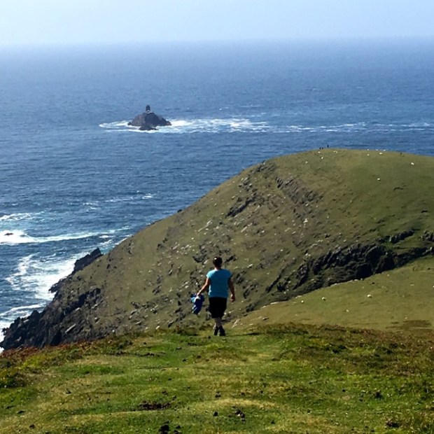
At the tip was a fine cut stone building whose purpose is a mystery to us but maybe connected to the Napoleonic signal tower that topped the island. The waves crashed relentlessly on the colossal slabs of rock that are favoured by all manner of nesting seabirds including at times visitors from both arctic and mediterranean waters.img_1227

img_1230

It was a place to savour and the hypnotic beat of the sea and the hazy divide between the earth and the heavens induced a feeling that the sign to Tir na nOg was possibly accurate.

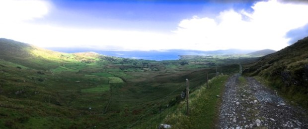
Finally turning away we retraced our steps to Tilickafinna and started up the steep slopes of the islands high point rising to 252m with the 2oo year old signal tower still waiting for an invasion.This was the site of another giant EIRE layed out in whitewashed stones to warn WW11 pilots they were heading over neutral territory. The third we’ve seen this summer, but only the third we’ve seen in 3 decades of exploring the west of Ireland.

img_1237

The undulating spine of the island was laid out ahead of us, the broad ridge offering us serene views in all points of the compass. Atop the next rise we stopped to puzzle over a small area of denuded ground, with the turves piled and covered, and a neighbouring patch of turned sods. Some experiment in erosion and regrowth ?

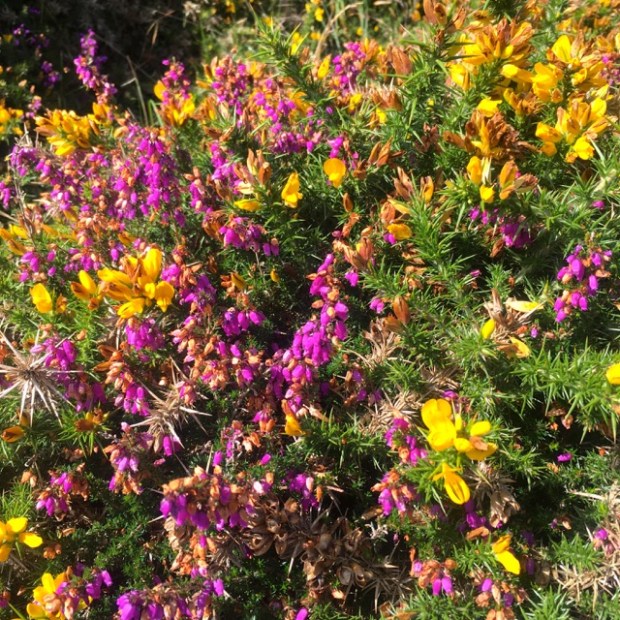
The coating of soil was certainly very thin but seemed tough and well drained and supported a fine crop of dwarf gorse and heather, both vibrant in the sunshine.

img_1258

An ancient, skilfully constructed, ditch and wall ran beside us with stonework that would not have looked out of place in a gallery but was a beautiful and effective sheep barrier.

img_1257

Looking back up at the signal tower it was with a slight sense of regret that we climbed the final hill and came back down to the sound where we watched a lobster boat being tossed about in the swirling gyres while waiting for our ride to the rest of Ireland.

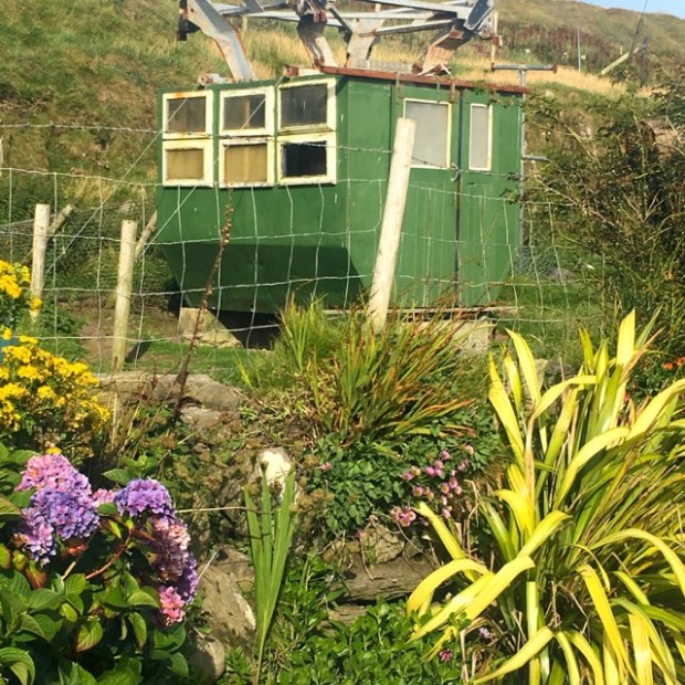
Driving away from Dursey we had one more sight of an island artefact. A few miles down the road the old cable car was now serving as a chicken coop in a farmyard garden.

img_1266

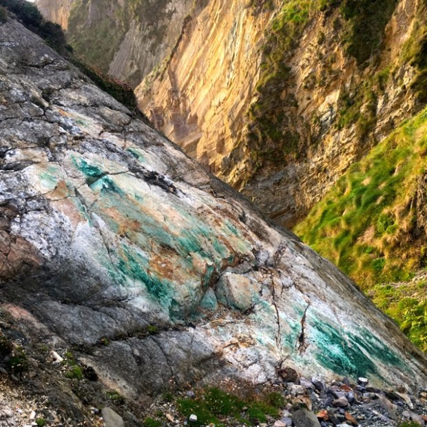
We parked up for the night outside Allihies at the site of an old copper mine and marvelled at the bands of rock making Knocknagallaun into a really groovy mountain.

img_1269

I’d read about a mine collapse around there recently,suddenly  creating a hole big enough to swallow a couple of tractors so was a little wary of the ground opening up beneath me but had to have a look at the copper streaked quartzite seam that been extracted from the old red sandstone during the days of this short lived but large scale local industry.

img_1271

A fine night slowly segued into a misty morning where the low visibility made the WAW signboard useful for determining our whereabouts.

The day was spent with our friend in Castletownbere and the night at the top of the Healy Pass hugging the sheltering mountainside as a gale funnelled through the cleft in the rock that the serpentine road wound it’s way through.

img_1277

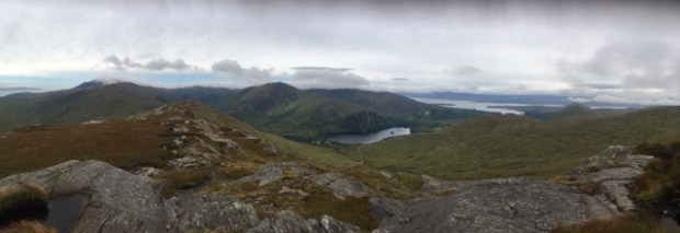
The 8 mile road was built during the famine times in 1847 “to help prevent starvation”! from Adrigole Bridge in Co Cork to Lauragh Bridge in Co Kerry on the route of an ancient track known as Bealach Scairt, The Way of the Sheltered Caves, and the pass was the county border. At dawn the following morning I set out up the dividing line in an attempt to scale the 2nd highest peak on the peninsular, Knockowen at 658m.

img_1282

The line from the Thin Lizzy song Whiskey in the Jar was reverberating in my head “As I was goin’ over the Cork and Kerry mountains”and the light,very slowly, revealed a wild landscape of rock and bog.

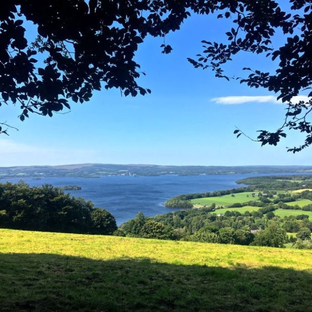
As I climbed higher Glamore lake and the Kenmare River estuary to the north came into view but i was soon in the clouds and decided the summit, lost in the mist, could not compete with the breakfast that awaited in the Tranny and retreated.

img_1287

img_1291

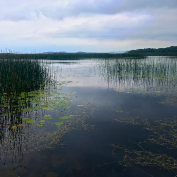
And so to our second destination of the trip, Derreen Gardens, nestled into 60 acres of a sub tropical like sheltered cove at Lauragh. In 1870 the Marquess of Lansdown embarked on an ambitious plan to transform the bare rock and scrub oak around his house into a luxuriant woodland garden. As Viceroy of India and Governor of Canada he was able to bring back many exotic specimens and many of the trees and rhododendrons in the gardens were planted at that time. The mild moist microclimate is ideal for the huge collection of tree ferns that line the 12km of paths we explored, winding through the slabs of sandstone down to the seaweed shoreline where seals and otters are often seen.

img_1302

img_1299

This is one of the few places where the “little people” live. Called Derreenies they are elusive folk and the last known sighting was in 1855. It was fairly easy to spot their houses amongst the mossy boles but they often seemed vacant.

It was a still and dreamy environment of which I have little to say other than to recommend a visit if your ever in the vicinity.

img_1344


THE LOUGH DERG WAY : Limerick to Dromineer

IMG_1043

One of the nearest long distance trails to home, the Lough Derg Way stretches for approx 70 km and having done a couple of sections and loops on it previously, I wanted, before the summer was out, to complete the whole thing in one go.

Travelling through three counties it has an easy trailhead to get to on public transport, starting in Limerick city and then following the tow path of the disused Guinness or Park canal to a short leg along the Shannon. Crossing it into Clare alongside the old Errina canal  and the Ardnacrusha power station head race you rejoin the river to enter O’Briensbridge.

From there it’s another waterside walk for a couple of km before heading up on small backroads to Killaloe, over the bridge into Tipp and a long ascent on tarmac and moorland path up and over the Arra Mountains with views across Ireland.

Cross country from there to the shores of Lough Derg, which the trail stays close to for the rest of its winding route to the finish at Dromineer. I believe there are plans to extend the way to the top of the lake at Portumna which would then also include Co Galway.

My bus to Limerick was 40 minutes late so i didn’t get going from the Hunt Museum till nearly 4 o’clock, setting my sights on camping up somewhere around O’Briensbridge roughly 15kms away.
IMG_0945

Turning my back on the busy shopping streets I followed the old Limerick Navigation Canal, opened in 1799 and closed in 1960, it avoided shoals on the Shannon and allowed passage up to Lough Derg and from there into the Grand Canal to Dublin a journey that took 4 days.IMG_0947

Passing by the sunken wreck of a barge and the derelict warehouses I stopped on the old quay with its cut stone work and abandoned crank, once used for loading and unloading the cargo , and marvelled at how a once busy transport route, teeming with industry was now, literally, a backwater.

IMG_0948IMG_0949

Back in 1831 it would have cost me 2pence to travel by boat to O’Briensbridge and 100,000 people a year used the route. Now as we left the city behind,(and above), the canal was a place for graffiti artists and wildlife.

IMG_0950IMG_0953

And pedestrians of all kinds.IMG_0954

Unfortunately I hadn’t seen the comment on the Irishtrails website about the route being closed on the University of Limerick campus so as i approached the confluence of Park canal and river it was a bit of a shock to come up against harris fencing and warning signs.

Fortunately “desire paths” as they are known had forged a route through, round and over the many obstacles. It’s hard to stop a determined walker on his passage of choice.               A refurbished track was being laid from the uni into town which will be great in the future but was a bit of a hassle for me.


Then I was in the clear again alongside the river, with people out enjoying the sunshine.

Looming out of the woods by my side, the remains of a tall stone building appeared. This was Plassey Mill a six story corn mill from 1824 which, thanks to a 10ft drop in water level here, was the most productive mill in the area when it was operated by the Russell family, themselves the most renown millers in Munster. For some reason the corner tower was left when the rest of the building was demolished in the 50s.

IMG_0966

This was once a tricky section for the horse drawn barge men. The towpath alongside the river was so high and narrow that the horses often fell into the river and at times of flood would be completely submerged, forcing men with long sticks to go ahead and feel for the  path beneath the water. A little further along was a greater challenge, to cross the 450ft of the Shannon and get into the Errina Canal on the Clare side. The river now carries a fraction of the water it did before Ardnacrusha hydrostation was built. The head race of the power plant, above O’Briensbridge, takes the first 400 cubic metres of flow, leaving the old course of the river a mere 10, unless of course, as all to often happens these winters, the ESB has more than enough.

Back in the day it was a struggle to cross against the currents and passengers and horses would have to be transferred to smaller vessels and ferried or winched across.( Mind you, not as much as a struggle as when the Navigation first opened. There was no tow path for horses and the barges were manhauled up the canal and sailed or paddled on the fast flowing river section.)

A bridge needed to be built and in 1842 the Black Bridge was finally opened, carrying in 1 week over 4000 passengers and 76 horses.

IMG_0971

Although still tresspassed upon by fisherman it is now closed and I had to use the more modern Plassey road bridge at the uni.IMG_0970

The next section on the Errina canal was very tranquil. Less than 5km from the city I was in a green and leafy corridor with water to my left and cows grazing the fields to my right. Faint shouts came from the distant playing fields and a poignant memorial to a fellow walker left me contemplating his fate.

At the hump backed bridge guarded by a white goat I joined the dead end road that led, after about 3km, to the massive grassy banks of the Ardnacrusha head race. This is now the navigation course for any boat wanting to get from the Shannon to the Atlantic and involves a double chamber lock that drops 100ft at the dam end. Having manoeuvred our little boat through the locks of the Grand and the Barrow I’m impressed. The next biggest drop in the British Isles is 19ft I believe. When completed in 1924 the hydro scheme was the biggest in the whole world and produced more energy than the entire country used.

IMG_0997

At Clonlara the Way rejoins the canal for a few km till it finishes at the Shannon again below O’Briensbridge. I had already hiked that section awhile ago and decided to continue on the slightly shorter option of following the head race into the village, where a tree drowned in the floods last winter had been decorated by the school kids.

IMG_1002

With the evening drawing in I stopped briefly for some liquid refreshment in the only bar of many in the village still open for business and carried on into the sunset. Finding a quiet spot was not a problem and I made camp on the sheep mown grass of the bank and after a soup and sandwich , crawled into the tent under a full moon in the clear cobolt sky.IMG_1008

The clear sky remained in the morning as I broke camp and headed on atop the bank to the  Parteen weir where the head race begins.The hills of Clare and Tipperary rose upon either side of the waters there as the Shannon widened into the bottom of Lough Derg.

I was soon directed away from the lakeshore onto a length of busy main road, thankfully turning off after a few 100m, and up a wooded lane with the beginnings of autumn showing in the leaves that formed a canopy above.

IMG_1018

A sign at the top informed me this was on the route of Sarsfield Ride, the site of a dramatic  episode in Irish history.

After the defeat of the Jacobites at the battle of the Boyne in 1690 James II fled to France and the remnants of the Irish army retreated to Limerick pursued by William who had swept down from the north seizing most of Leinster, intent on securing a river Shannon crossing at Limerick. Most of the command were for abandoning the city to Williams forces fearing the defensive walls were no match for his mighty new siege cannons on their way across the country to Williams camp just outside of Limerick. Not anticipating much resistance on their journey across subdued territory the convoy had only 100 men and Sarsfield, a general in the Irish army, hatched an audacious plan to intercept them.

Riding out under cover of darkness with 600 hand picked cavalry he headed north through friendly County Clare on the route I was now walking. Crossing at an unobserved bend in the river just north of Killaloe they stealthily made their way east into the hills. As luck would have it one of their scouts came across a wife of a Williamite soldier on the convoy whom he plied with whiskey and she revealed that the password for the siege train was “Sarsfield”.

The large convoy of formidable weaponry had made camp at Ballyneety just 10 miles from Williams position and the story goes that, when sneaking up on them after a long ride south, Sarsfield himself was challenged by a sentry for the password.                                                   “Sarsfield is the name, and Sarsfield is the man” he is said to have roared as his men swept in and quickly dealt with the sleeping troops.

Then gathering up the 150 wagons of stores, ammunition, powder, motor guns and canons whose mussels he rammed deep into the earth he set off a hell of an explosion that lit up the sky and was heard in the Williamite camp. Taking all of the enemies horses with them they hightailed it north around the top of Lough Derg at Portumna, back through Clare to arrive in Limerick as heroes.

Without the massive siege guns William had to wait for more to arrive from Waterford and the Irish had time to regroup. Morale was high after their victory and when the attack did come it was successfully beaten off, helped famously by many rock throwing local women.

IMG_1021

And so, following in the footsteps, or hoof prints,of heroes I made my way to Killaloe for breakfast, fortifying myself for a long climb into the Arra Mountains of Tipperary on the other side of the Shannon.

IMG_1030

The small road that led me up out of Ballina on the eastern side opened up views back down towards Parteen and across the Clare hills, with the forested slopes of Slieve Beamagh, the counties high point, rising above the waters.

The Way turned off up a narrow track strangely signposted to discourage cars.

IMG_1035

The sun was shining brightly in the morning sky and I was shedding clothes as I climbed up into the heather and gorse covered moorland. I was left to wonder why so much of the land surrounding me had been left to go wild and who owned it.

IMG_1036

IMG_1039

Skirting the edge of forestry I joined the road the leading to the masts that sit on the summit of Tountinna at 460m and contemplated having a cooling dip in the Black Lough.

IMG_1040

The high point of the Way reached, I stopped for lunch with a view and dried off my sweat soaked t-shirt and dew drenched tent. From here, with good eyesight (maybe binoculars) and visibility, you can see into 9 counties from the Twelvepins and Maumturks in the west to the Slieve Blooms and Wicklow Mountains in the east. The whole of Lough Derg is laid out before you complete, on this fine day, with a flotilla of boats competing in the Optimist dingy national championships at Dromineer. My phone camera could not cope.

The trail led steeply down from here to the site of the Graves of the Leinstermen, where the King of Leinster and his men, on the way to High King Brian Boru’s place to marry his daughter, were ambushed and killed in an attack planned by Brian’s wife Gormlaith who did not approve of the match. Seems harsh.

IMG_1045

From here the route is changed from that shown on the ordinance survey maps to climb Laghtea Hill with its shiny steel cross replacing an earlier concrete one destroyed in a storm. The hills here are mainly slate and a lot of old mines and quarries dot the landscape

IMG_1047

From here I started to have problems with the trail being overgrown and untended. Another steeply stepped path ran down through bracken and brambles adjoining a young plantation of conifers which threatened to overwhelm the track.

A short tarmac section later I was again directed off road, this time at the edges of fields through thistles, before arriving at a more accommodating farmers land who didn’t electric fence me into the nettles and prickles but instead trusted me to cross his land without causing damage, admiring the lake view on offer.

IMG_1055

Reaching another road at a carpark known, not surprisingly, as The Lookout, I was way marked through a lovely section of mature mixed broadleaf woodland and down a lane past the award winning and attractive old church and graveyard at Castletown and the ruins that supplied the name.

Minutes later I gratefully joined the families cooling off in the waters of Lough Derg.

IMG_1063

An hours R and R later I shouldered the pack once more and continued on through what was obviously a grand estate of many acres, the solid stone wall and forest of mature trees hiding whatever mansion lay within. The land here on the Tipperary side was seemingly much richer than the Clare side across the lake and the houses reflected that.IMG_1064

This was obviously a much desired location and exclusive looking lake view properties lined the road into Garrykennedy where the marina, busy gastro pub and expensive motors in the car park added to the effect. After a meal and pint I found myself a discreet camp.

IMG_1073

The tent survived the nights rain and the day dawned fair, but it wasn’t due to stay that way.

With 25km left to go to Dromineer I was hoping to make quick progress around the lake before the weather changed. It started well enough on a stretch of road away from the village then the way marks lead me onto farmland where the grass was tall and wet and I had trouble finding the markers at times.IMG_1079

Leaving the cows behind I was led on a lovely path to a well managed woodland, well tended, with a trail to match.

Crossing a lane that led down to Youghal Harbour I followed a” new improved” farm track between park like grazing meadows, with huge mature trees generously strewn across them, that led me down to the enchanted setting of a holy well.

IMG_1087

St Conlons Well had benefitted from the same facelift bestowed upon the land and woods around it and was “well” tended with a planting of flowers and a multitude of offerings hanging from the thorn tree. I have visited many a holy well and sadly a lot are falling into an unloved state of ruination but not this one. I filled my water bottle and was still awhile.

IMG_1091

Unfortunately St Conlon could do nothing for the conditions of the Way that awaited me.

The manicured farmland gave way to wilder country with ragwort and thistle taking over neglected fields as I approached the low flat lake side area known as The Callows. This land was crisscrossed by wide and deep drainage ditches and the trail proceeded along the top of flood prevention banks that were choked with under, (and over), growth.

IMG_1095

I struggled on constantly looking for a way around the obstacles. Everytime I tried a short cut across grazed fields I came up against another impassable ditch and had to fight my way back onto the bank of briars, nettles and waist high grass. To cross the ditches the route forced me a long way up them to a bridge, only to go a long way back down them on the other side. Frustrated by the nearly impenetrable scrub I wondered why the bridges couldn’t have been placed in more appropriate places.

IMG_1096

I understand that many of the walking routes in Ireland rely on the good will of the farmers and that there is no “right to roam” and very few rights of way but I also know that under the National Walks Scheme launched by Minister Eamon O Cuiv nearly 2000 landowners on 49 trail routes are paid an average of €1000 annually to manage the tracks. In 2011 the local media reported that the Lough Derg way had been reconfigured and relaunched with many sections being taken off road. This had been achieved by an investment of €115,000 to “support landowners to maintain the trail”.

IMG_1097IMG_1099

Walkers, especially those from abroad, do not want to hike long distances along the roads.But equally there is no point in leading them into an impenetrable morass on a National Waymarked Way with no escape route.

IMG_1102

I found my escape route when I arrived, wet and weary, at a road. I had been looking forward to the lakeside sections and there was another 3 or 4km length coming up, but with the amount of time it had taken me to cover the last overgrown few km I didn’t think i’d make my rendezvous in Dromineer on time. And anyway I didn’t relish the thought of more fighting through the vegetation.

So I regretfully gave up on the Lough Derg Way and charted another course along the back roads for the remaining 5km or so. It was pleasant enough, passing through quiet farming backwaters and joining up with another walking route out of Dromineer.

Arriving just before the heavens opened i had time to check out the castle by the harbour then took shelter in a bar with a welcome bowl of leek and potato and await my lift.IMG_1115

Overall it was good hike but the overgrown section on The Callows was a serious flaw which could have denied me the best bits. I’ll have return at some stage to find out.IMG_1121