hiking ireland

LOUGH GUR: A Midsummers Night’s Dream

Wondering where to go to celebrate the shortest night/ longest day/mid summer Soltice I thought of Lough Gur in Co Limerick, a place I hadn’t visited in many years.

A sacred site for thousands of years and a place called home since Neolithic times I knew the area was chock a block with ancient sites of importance throughout the ages. And beautiful. And Irelands largest, and possibly oldest, stone circle – aligned to the midsummer sunrise- was still a place where the Soltice was celebrated.

So off we went, meeting our friends at the small car park by the circle where a few folk had started to gather in the evening sun light, making camp in the field owned by the friendly custodians of the land around.

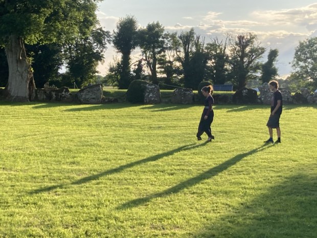
The circle is unusual in that the stones are continuous and have a big bank of earth behind them, creating a big enclosed sunken space that creates an audio delay effect when sounds created in the circle bound around the stones.

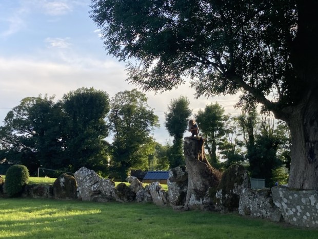
Massive and ancient ash trees grew from the bank in places, some hollow and showing their age but still magnificent, I only hope they don’t succumb to the scourge of Ash dieback. There are some particularly significant stones, including a huge slab weighing over 60 tons- the Healing stone- where I lay my back against it in the hope of better things. It is also the stone orientated to the mid summer sunrise.

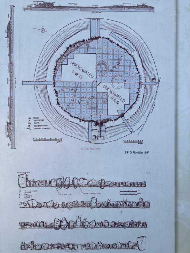
The entrance to the circle is through a stone lined passage through the bank aligned NE/SW and through which the setting of the midsummer moon could be observed in the V notch opposite in 2500bc. There are numerous other alignments and orientations amongst the 113 stones in the 46m diameter circle which seem to link it’s ritual purposes to the various Soltice and equinox throughout the year but we will probably never understand what went on.

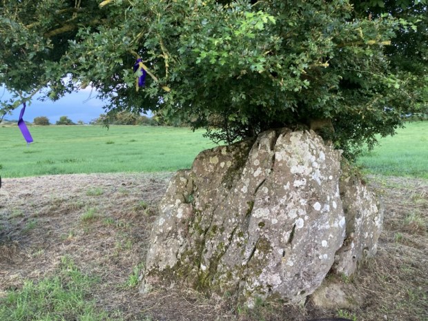
There was also a grouping of smaller stones where some votive offerings had been placed, this I discovered later was called the Harp Stone and was moved for the placement of the instrument- perhaps to avail of the sonic properties of the circle.

As the sun started it’s slow decent towards the horizon we went off to explore the immediate area, first to another stone circle, smaller, more spaced out, set in open country with a venerable fairy thorn growing out of a gap in one of the stones.

We wandered towards the hill to the east, hoping for a view of the lake and surroundings, passed an impressive 3.5m tall standing stone on a slight lean after all these years. It was on an ancient sunken track running north- south past the foundations of several hut sites and prehistoric field boundaries.

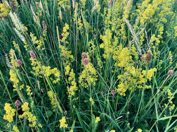
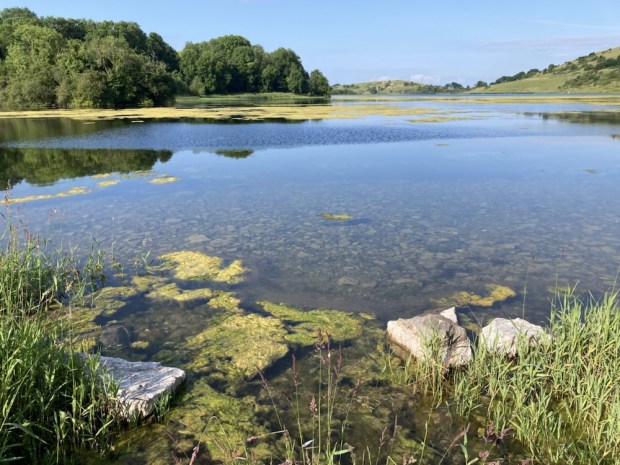
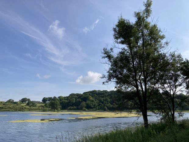
The hill behind it that we climbed was rich with wild flowers and variety of grasses, never having been disturbed by ploughing or reseeding because of the amount of rugged limestone protruding from the ground. Lady’s Bedstraw was glowing in the golden light as we reached the hilltop to gaze over the lake beyond.

As the short night descended we returned to the campers and a fire for awhile before getting a few hours sleep as some of the celebrants placed nightlights on the stones and made music and song.

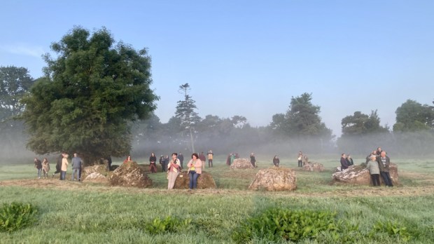
Up at 4 am it was too dark for my phone camera to record the faithful circling the grassy inner space in hooded cloaks and bare feet. The vibe was a mix of mysterious cultish ritual anticipation and warm up for a midsummer song and dance. Observers sat and stood atop the earthen bank whilst others started to gather in the inner circle.

An elder, a master of ceremonies, informed the crowd of historical and geographical facts relating to the circle as well as associated myths and legends before leading the song and dances. Other more ethereal voices took their turn and a circle of hand holding drew the energy up through the participants.

Tiring of the more rowdy celebrations we took refuge in the hushed reverence of the nearby smaller circle, where the open prospect allowed for a view of the rising sun.

A beautiful clear sky, a hazy mist drifting from the dew bespangled grasses towards the glowing ball of the rising sun, the birdsong mixed with quiet voices of expressed awe all made for a surprisingly emotional experience. I don’t think I’ll experience a midsummer like it again.

The sun had reached the giant Grange circle when we returned to the campers and the celebrations continued. We breakfasted and listened to a friends live ambient music show broadcast live from the Lough Gur Heritage Park on the far side of the lake, our next stop.

The Lough Gur area is unique in Ireland for the range and density of field monuments and we drove past a good few ( wedge tomb, ring forts, early church, castles, standing stone etc) on the way to the visitor centre where a walking trail lead us past more remnants of 8000 years of human settlement.

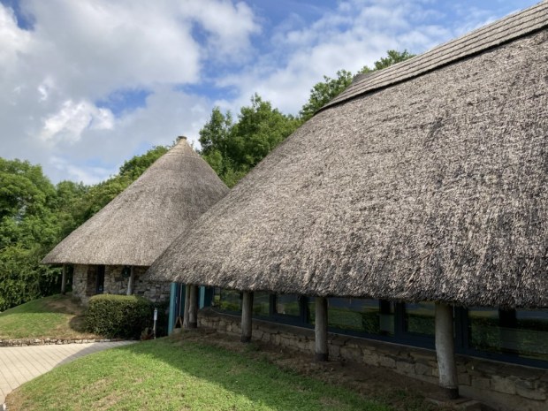
Wandering backwards and forwards in time we started at the recreated Neolithic buildings housing the visitor centre and climbed up past The Spectacles, a collection of hut foundations and small field walls in the shape of a pair of glasses.

A stiff climb up stone steps had me panting at the viewpoint overlooking a landscape inhabited by countless generations of ancestors living lives unimaginable to us now. Excavations carried out over 20 years from the mid 1930’s by Prof O’ Riordain in the Grange circle had uncovered over 400 flint blades, scrapers and arrowheads and 1000’s of sherds of pottery and the bones of many wild and domesticated animals. Earlier, in 1847, when the lake level was lowered and drained for some reason a massive amount of ancient objects were discovered. Our overall knowledge of Neolithic life in Ireland has been hugely informed by the Lough Gur finds.

Stone age, Bronze Age, Iron Age, all the way through to the Middle Ages and beyond, relics are represented here. We gazed out at Bourchiers Castle, nestled in the thick woodlands granted to the Earl of Bath with 1000 acres 20 cabins and a load of cattle after being confiscated from the Desmond’s in 1580 after a failed rebellion, before returning to the lakeshore on a narrow path through the trees.

A Wishing Seat, where lovers who sit together will never be parted, was decorated with various offerings – a mythical antiquity very different to the functionality of the lime kiln next to it.

The remaining leg of the sunlit path took us past the remains of a 1680 pigeon or dove house, an important source of meat, eggs and fertiliser and the site of a crannog from perhaps 1500 years ago, once a man made island but now connected by marshy land.

We finally returned to the visitor centre to gaze at excavated finds in showcases, watch animated audio visual displays and dress up.

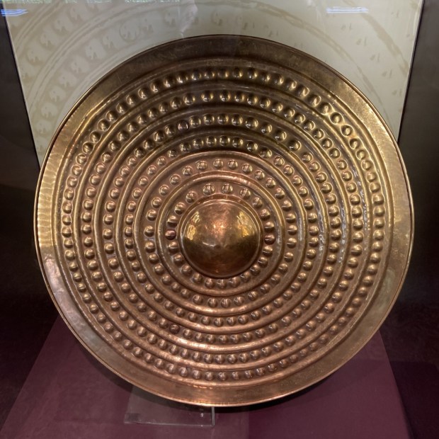
A costume fluid mashup perhaps but like the copies here of the real artefacts that were taken away to Dublin, it was only a recreation- the reality is lost in the mists of Lough Gur.

NORTH KERRY WAY: Kerry Head to Tralee 13/14th April

20/24km

The North Kerry Way starts in Tralee and goes north up the coast to Ballyheigue before doing a loop around Kerry Head. I left my van in Ballyheigue ,did the loop on the first day, slept in the van,continued to Tralee the next day and then got a cab with the dogs back.

IMG_2086

An old narrow boreen lead us out of BallyheigueIMG_2087

climbing up to higher ground passing the ancient earthwork of An Clai Rua [track of the red ditch] a 6 foot wide bank that runs intermittently from  Kerry Head all the way to Co. Limerick.

IMG_2106  A much quieter way than it’s neighbour the Dingle Way through a landscape dotted with many signs of abandonment both ancient and modern.IMG_2088 IMG_2089

I took a detour of a couple of kms down towards the sea to visit the well of St DahalinIMG_2092

known as Tobar na Sul [The spring of the eyes] which is reputed to heal blindness and still visited by people who come to bath their eyes in the holy waters. We picked up a huge greyhound there who was determined to follow us IMG_2099

and it took an hour to find the owner and move on up the gorse lined bog road to Maulin mountain.IMG_2101

Good boots were needed on a long wet stretch of sunken path that must be a river in the rain.           IMG_2102

Towards the top the track became wide and open again and the views opened out to take in the mouth of the Shannon all the way down to Limerick and across to the south Clare coast and Loop Head lighthouse.

IMG_2105 IMG_2104

A tiny path lined with newly and optimistically planted trees IMG_2107 took us over Triskmore Mountain and down to a track leading west, passed more hounds IMG_2109 and dumped rubbish IMG_2110 to the end of Kerry Head where the farm would not win any prizes for eco awareness. IMG_2113

Turning south the expanse of Tralee Bay lay before us from the Slieve Mish range all the way west to Mount Brandon at the end of the Dingle Peninsular.The fine grassy fields were in south facing strips down to the sea from the road we followed past more old cottages back to Ballyheigue Bay.IMG_2114

IMG_2115  IMG_2116 IMG_2118 IMG_2120

Next morning we headed off down about 8km of wide empty beach going inland briefly on a sluice bridge over the Tyse river IMG_2127

and across the flat heath Cul Tra “the back strand”, the dogs excited by the rabbits and skylarks.

IMG_2129                            IMG_2130

Back to the beach above Banna where the view was distracting enough for me to miss my path

IMG_2132                           IMG_2138

off the beach which meant i had to cross the luckily low tide sands of Carrahane Strand to get back to the road.

IMG_2142                          IMG_2144

The road was fairly narrow and fairly busy with no verges or easy escape from the traffic with the dogs so i was glad when we crossed the old Tralee to Fenit railway line and came down to Spa harbour.IMG_2151   IMG_2152

In the 18th century this was a popular and fashionable location when many of the large local English population came to take the mineral waters there. I don’t know if the sea wall i now followed was part of the relief scheme work carried out during the famine but half way along is a small bridge called Meal Bridge and was where the workers collected their Indian Meal payment.

IMG_2155     IMG_2153    IMG_2156

A deep narrow channel through the shallow water of the bay leads to “The Point” where the Tralee shipping canal brought freighters safely up the 2 1/2 kms to the city for 100 years.

IMG_2158     IMG_2159    IMG_2161

It passes the windmill that was restored by local people and continues to grind grain and now also holds a museum of famine emigration in ships like the Jennie Johnston whose replica was built here recently.

IMG_2165      IMG_2164

IMG_2167

The Ireland of today is in a very different place toothed and all the talk of austerity and the hardships of water charges are bought into perspective when you walk, blissfully, on “amenity areas” overlaid onto the spine of a desperate past. The landscape is/was beautiful, I only hope it gave some succour to the sufferers of the past.

ROYAL CANAL: Coolnahay to Ballymahon 7th April

28kms

Another cold clear night under a micron of nylon and a frosty start to the day. There was a skin of ice over everything and no camp fire to dry/warm things over so we put the tents away wet hoping to dry it all out at camp that night. 


After reclaiming my battery pack that had been charging in the tea room all night and a chat with the friendly lock keeper, who we have awarded best of 2015, we headed off down past his canal side gardens and tree planting on a newly laid walking / cycling track. There was a rash of bridges and locks over the next few kms some sporting interesting graffiti and some with neatly kept flowerbeds. 


Then quite a long straight section across empty flat land on the approach to Ballynacarrigy. 


The lock keeper of the year had given us fresh scones for breakfast but we needed more so we stopped at the impressive harbour there for coffee and chocolate and marvelled at the unknown or celebrated attractive villages we were discovering on the canal. 150 years ago this backwater was a important trading centre and had in the early seventies formed the first Royal Canal Ammenity Group which kick started the whole restoration process. By 1990 the canal had been, bit by bit, cleared and rewatered from Dublin to Mullingar but it took another 20 years to complete all the way to the upper Shannon at Tarmonbarry. 


We carried on towards the bog at Ballymaglavy passing an abandoned canal house that would have made a fine home for the night. 


We went over the beginnings of the river Blackwater 

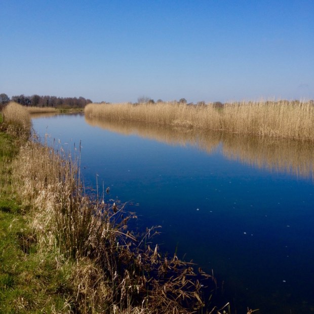
and across a  vast expanse of bog where the turf was being harvested in a way we hadn’t seen before. 


There was yet another of the meloncoly bridges to nowhere

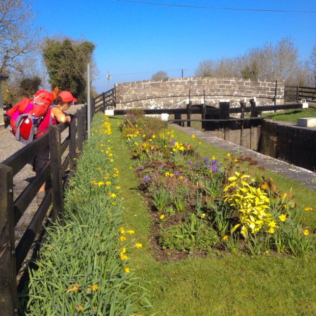
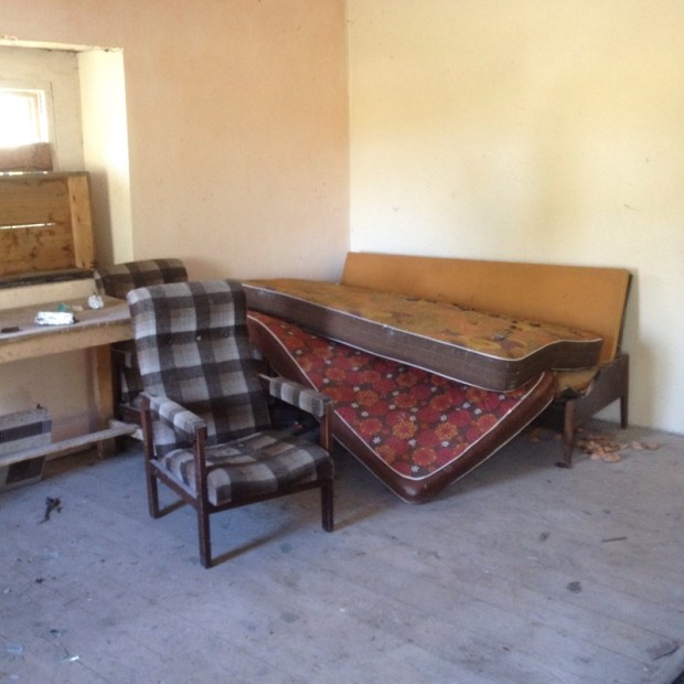
and a derelict lock house with an interior that needed a severe makeover. 


We crossed over the river Inny and past an airfield on the outskirts of Abbeyshrule where we had soup and sandwich to get us through the heat of the afternoon for another 12kms. This section of the canal is very twisty turns with a series of curves and bends following the river valley and is also the most level with 11kms between locks. 

By the time we got to Ballybrannigan harbour I was ready to join the swimmers

but we needed to go on a bit further to get supplies and camp. Sally headed into Ballymahon, celebrating its massive investment by Centre Parcs, to get dinner while I took all the kit on to Archie’s bridge and set up camp. 

A nice sheltered spot by old derelict canal warehouses kept us warmer than previous nights but it had been a long hot day and my track buddies feet were suffering. 


WILD NEPHIN AND THE BANGOR TRAIL

DSCN2475


I could have been the loneliest man in Ireland.
Camping out on a shoulder of Slieve Carr, facing west across the sea of bog towards the great pyramid of Slievemore on Achill Island,I was truly, deeply alone.
On the Bangor Trail in the Ballycroy National Park , part of the newly designated 22,000 acre wilderness area in the Nephin Beg mountain range, this was as far as it’s possible to get in Ireland from roads, buildings or people.
I had a few sheep for company and midges, countless millions of them swooping and swirling like a murmuration of starlings.
Retreating to my tent after dinner I swear I could hear them buzzing in their multitudes, like a swarm of bees.

DSCN2481

Slopping through sucking bogDSCN2521 whilst being eaten alive by bloodsucking insects might not appeal to the average sedentary vacationer, but I loved it.

I loved the vastness of nothing. Nothing but mountain sky and bog and a tiny thread of a trail weaving its way north to south from Bangor to Newport in County Mayo.DSCN2487

An old drovers road, a trade route,the way home for the few far-flung home steads that once clung to a precarious living in this wild place.

DSCN2479

The great naturalist Robert Lloyd Prager wrote of this place,

“Where else even in Ireland will you find 200 mi.² which is houseless and roadless. Nothing but Brown Heather spreading as far as the eye can see…I confess I find such a place not lonely or depressing but inspiriting. You are thrown at the same time back upon yourself and forward against the mystery and majesty of nature and you may feel dimly something of your own littleness and your own greatness.”

I had started out from the old bothy DSCN2555 at the Letterkeen looped walks trailhead and was very alarmed on my way there above Furnace Lough to see the ominous spread of Rhododendrum Ponticum. In some areas it was already established into dense woodland and was clearly on the march across the hills, thousands of single stems standing sentry in their shiny green foliage.

DSCN2459On a recent hike through Killarney National Park I had witnessed the results of a 30 year war waged against the foreign invader and the news from the front was not good.
What would happen in the wilderness area where the land management policy was going to be hands off I dreaded to think.DSCN2546


DSCN2461

This new initiative sees Coillte working with the department of arts, heritage and the gaeltacht, the national park and local landowners to set aside an area to go wild and to go wild in. The first of it’s kind, the plan is to eventually have 1 million hectares across Europe going” back to nature”.

I had decided on a circular route. 30kms on the trail to Bangor, then hitch a spin down the N59 east for about 14kms to where i could join up with the western way. From there it was 25kms back south, mainly through forest, to the Letterkeen bothy.

DSCN2464

A few yards from the bothy I crossed the Altaconey River and not long after crossed it again on a new steel footbridge.

DSCN2466

This end of the trail was dry and solid underfoot on a well marked stony track.

DSCN2468

After about 5kms, at a point where one of the loops veered off to the rightDSCN2471 I came upon one of the wooden hut shelters erected by the Mountain Meitheal volunteers and had lunch while reading the log book there and soaking up the silence .From a notice on the wall I discovered that there was another hut on the Western Way on the other side of Nephin Beg and decided to stay there the following night.

DSCN2474

Shouldering my pack I carried on up the trail and, leaving the forestry behind, headed into the vast open landscape with the brown bulk of the mountains rising from the bog ahead.

DSCN2519

The going became harder and the ground became softer as I crossed what is basically a giant sponge. In places sections of boardwalks have been constructed to carry you over the quagmire, but over a 30km trail it could only be a token gesture towards dry boots.It was calm and still and any resting resulted in an attack by the midges which convinced me to head to higher ground to camp in the hope of finding a breeze.

DSCN2493

In the morning I headed down to the river valley that cut a meandering course through the boggy wilderness till I reached the broken footbridge across the Tarsaghaunmore River where I managed to scramble across on the wreckage without wetting my socks.

DSCN2506

A couple of hours later, as I crossed the purple heather covered hills on the approach to Bangor I spied a lone figure who turned out to be a park ranger, out checking on track work, as surprised as myself to meet anyone else out there . We talked about plans to establish other huts and  camping areas, the on going track establishment and the need to balance increased accessibility with an unmanaged “wild” environment.

DSCN2527

Another half hour brought me into town where,after a pint and a sandwich, I got a lift.  After a day travelling across the landscape at walking pace, the car seemed to hurtle us over the bog at brake neck speed and 10 minutes later I was back to 4kms per hour on the Western Way.

A long boreen led back towards the mountains and an isolated farmhouse on the edge of the forestry .

DSCN2530

Entering the plantation took me into a different world. From the wide open spaces of bog and sky and seemingly limitless horizons my world became shrunk and enclosed.

DSCN2541

The forestry tracks made for easy hiking and a couple of hours and 10kms later I gratefully came upon a sign that led me up a side trail to the shelter nestling under Nephin Beg. This trail continued up towards Scardaun Lough and the pass through the mountain range.

DSCN2536

Reading the hut log book I could see that people used the shelter as a base before tackling the peaks above that rose to 720mts on Slieve Carr.Feeling   too weary to contemplate such exertion I cooked up my dehydrated meal, erected my tent inside the shelter to avoid the midges and slept.

In the morning the remaining 10 kms back to the Bothy did not take long. I past areas where Coillte had been doing some selective clearing

DSCN2539

and it’s going to be very interesting to see how this exciting experiment in “re-wilding”goes.