
On a (too) short break in Spain last week we tackled the local section of the GR7 route that works it’s way 1900km from Tarifa on the southwestern tip of the country, through the regions of Andalucia, Murcia, Valencia and Catalunya.
And the Spanish trail is only a small part of the International E4 route, starting in Portugal and traversing Spain, Andorra, France, Switzerland, Austria, Hungary, Romania, Bulgaria, Greece and finally Cyprus making up an epic 10,500 km. Thats some hike.
Unfortunately we didn’t have time to do the whole thing and so made do with a 500th of it.

Starting out in the early morning light we climbed a long way up out of Rio Gordo north, over the main road towards Malaga, past a lot of the prickly pears that been struck down with the white fly infestation of the cochineal beetle that is a relative of the one that produces the vivid red dye and ironically the original reason for the introduction of the prickly pear, its home and food source. But for some reason the population of this species is out of hand and has wiped out the iconic pear across a large and growing area of Spain.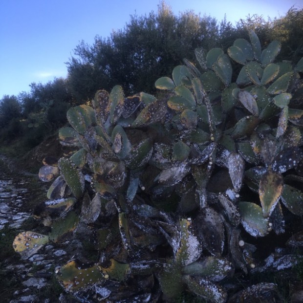
It took us about an hour to climb the couple of hundred mts up into the sun, levelling off at about 650m with fantastic views back down the sierra and on towards the imposing bulk of Dona Ana.
The wild flowers were a glory, mid April, and although a good few had obviously gone over there were plenty to admire, and smell, and gather seeds from.


Even though there had been very little rain all winter the fields of grain and broad beans were green and the hedgerows lush. The colours of the flowers were very vibrant in the sun and the buzz of insects became loader as the heat started to rise.

The broad open flatish land up on the high ground below the limestone peaks was obviously richer and easier to cultivate than the steep and stony olive groves of the lower levels and it was up here that the oldest and biggest fincas or cortijo seemed to be.We approached the crumbling ruins of one that was supposedly the birthplace of Andalusia’s famous Robin Hood figure Omar Ibn Hafsun whose rebel army controlled a vast territory in the 9th century, but had since been used to house a load of sheep in sheds above some ancient caves in the cliff.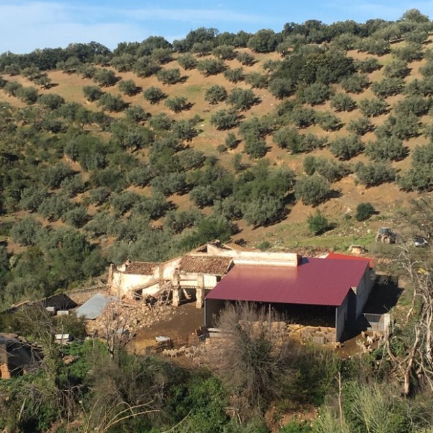
From here a narrow and sticky farm track that gathered on our boots as we went led us between the fields yellow with some weed or old crop (rape? mustard?) , across a little arroyo running with the previous mornings rain, and slowly down again to reach a road.


We hit tarmac for awhile at the Puerto del Sabar at 600m but the wide views and wealth of roadside flowers made it an enjoyable stretch until we crossed a river and turned up a narrow track and gained height again to reach a little hamlet with a bar and an interesting looking Casa Rural.


Climbing up and away from the houses on a track that heads southeast around the hillside we had our first view down the valleys towards the reservoir at Vinuela and beyond it in the distance the twinking Mediterranean .
Before too long we were approaching another fine old Cortijo, this one boasting a cobbled track and era (grain threshing platform. Not far beyond Sally got a bootfull in a puddle and we stopped for lunch by a fountain on the way into the elevated village of Guaro.


We needed the sustenance to fortify ourselves for a pretty big climb up out of the prosperous looking village and up to the crest of the hill at about 900m where we turned left to join an old railway bed that was built to accommodate mine workings in the mountains and led us eventually all the way to Ventas de Zafarraya.
We had more great views across the sierra and down to the lake and at one point there was strange bridge across the track whose purpose we could not determine.


We crossed into Granada province as we approached the end of our 8 hour 30km journey.The highest mountain in the area , Maroma, at over 2000m, came into view and soon after we passed through a short section of tunnel and through the gap in the ridge thats allows the road up from the coast and into the high plain beyond that is a very productive vegetable growing area. Many of the (presumably low paid) workers on the land here seemed to be immigrants from North Africa and we shared the plaza and bus stop with some of them.


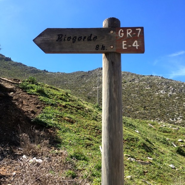
We passed a sign on our way into town that showed we were right on time.
8h. Eight very enjoyable hours on the GR7 E4. Only another 500 days to go.

Just missed you, down that way ourselves at Easter
LikeLike
Bernie, your still with me then. Fair play to you as we say in this neck of the woods.
We have a bit of stony cliff and have built a “house” down near Rio Gordo over the last decade so next time your planning a trip let me know!
LikeLike
Lovely area there, you did well to get a property. I’ve only walked in the winter months and realise from your pics all the flowers I’ve missed. Remember vividly struggling to walk on 3inch mud raised soles which couldn’t be shaken off.
LikeLike
Hi John. Yes its beautiful at this time of year. You seem to have hiked everywhere. Did you get to Fuerteventura?
LikeLike
Steve,
Yes I’ve been busy in my retirement. Slowing down now!
Been in bed with ‘flu’ so missed Fuerteventura – will wait till Autumn.
Where you next?
LikeLike
Im back at home with work commitments now so it will just be the odd irish trail this year im afraid, although i keep discovering interesting looking routes and destinations.
The lastest was a pretty unused Camino de Santiago that starts in Potes ( where we finished hiking to the Picos de Europa a few years ago, theres a blog on the trip) and crosses over the Cantabrian mountains heading south. Supposed to be a great weeks walking.
LikeLike
Looks like you had a fine day for it. I’m sure I’ve missed it along the way somewhere but what do those codes mean in terms of the G and E on the tracks and is it Spanish specifically or used throughout Europe?
LikeLike
Well now Milo;
The GR trail markings are used in half a dozen countries in Europe and stand for;
Gran Recorrido- Spanish
Grande Randonnee- French
Grote Routepaden- Dutch
Grande Rota- Portugese
They often help to make up the longer, multinational E routes designated by the European Rambler Association that crisscross the entire continent.
Now you know.
LikeLike